
Harrison Township ZIP Code Coverage
Six Census ZIP Code Tabulation Areas, commonly called ZCTAs, geographically intersect Harrison Township: 45405, 45406, 45414, 45415, 45416, and 45424. This is not a statement that every Township address receives all six delivery labels or that every part of any listed area is in the Township. Census ZCTAs are generalized, block-based representations of postal service. The six-area list is the geographic starting point; a live address still needs delivery verification and a county parcel check.
| ZIP | Township relationship | Postal locality | Record-search note |
|---|---|---|---|
| 45405 | One of the six intersecting Census ZCTAs | Dayton | A postal-city label does not define the Township. |
| 45406 | Northwestern Township geography; Northwest Branch context | Dayton | The branch address does not set its full service territory. |
| 45414 | Government Center and northern Township/Northridge context | Dayton or Harrison Township usage | Verify the exact postal label for each address. |
| 45415 | Intersecting ZCTA with a Sinclair Park local anchor | Dayton | Confirm the individual parcel and delivery address. |
| 45416 | One of the six intersecting Census ZCTAs | Dayton | An edge-area ZIP is not a Township line. |
| 45424 | Small geographic edge intersection | Dayton-area | Do not omit it, but verify each live address. |
The six-way intersection comes from the Census county-subdivision geography for Harrison Township in Montgomery County. It makes the ZIP code directory broader than a single Dayton label while preserving the limits of that geography.
Note: A ZIP narrows a location search, but it does not establish municipal or township inclusion by itself.
Harrison Township Six-ZCTA Geography
The official Census county-subdivision record identifies Harrison Township, Montgomery County, and provides the geographic base used for the intersecting-area list. Its 2020 population figure is 21,814. The Township is a large unincorporated area north and west of Dayton, so a county field, a tax situs, a school or fire district, and a postal locality can all describe different parts of the same address record.
The Census geography view provides the source context for the six-area finding.
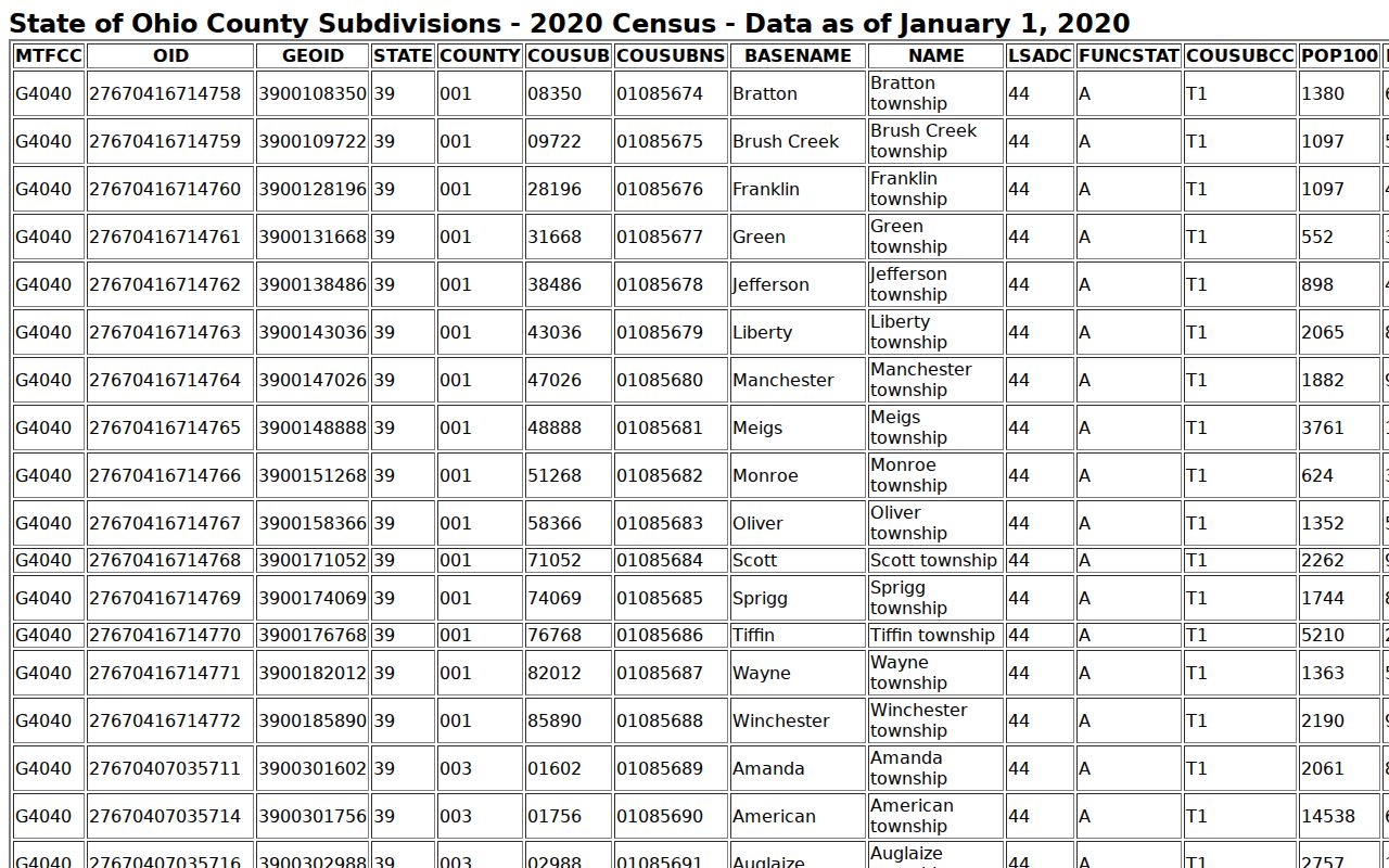
The geographic display supports a ZCTA intersection check, not a claim that postal boundaries exactly match township boundaries.
Keep the county identity visible in every search. Ohio has other Harrison Townships and a City of Harrison in a different county, so a city field alone can be misleading.
Verify a Harrison Township ZIP Code First
The official USPS ZIP Code Lookup is the delivery-address check. Its ZIP Code by Address mode has an optional company field, required street address and city/state fields, an optional apartment or suite field, and ZIP output. It also offers a city-and-state route and a cities-by-ZIP route. USPS warns that a result does not establish that a particular person or company is at the address. Use the output to validate delivery information, then shift to county records for property or jurisdiction research.
| Company | Optional in ZIP Code by Address mode. |
|---|---|
| Street Address | Required delivery-address field. |
| Apt/Suite/Other | Optional unit field. |
| City and State | Required fields for the delivery-address route. |
| ZIP output | Delivery result, not evidence of township jurisdiction or residency. |
A Dayton postal label can still belong to unincorporated Harrison Township. Retain the exact delivery spelling and postal city while separately recording the parcel, township, and legal-description fields that the county uses.
Harrison Township ZIP Search Keys
A ZIP is not always a search field. The Auditor, Treasurer, GIS, and voter tools each expect a different key, so pasting the delivery number into a field that does not accept it wastes time. The field comparison below is based on the documented public interfaces. It shows why a postal verification is followed by address, parcel, street, map, or county data rather than a ZIP-wide resident list.
| Official tool | Documented search fields | ZIP input? | Useful next action |
|---|---|---|---|
| County Auditor | Street address, owner name, or parcel | No ZIP filter captured | Enter street name without direction or suffix, then refine by number. |
| County Treasurer | Tax year plus parcel, owner, or property address | No ZIP filter captured | Use the verified address or parcel route. |
| Auditor Interactive GIS | Address, street/intersection, coordinates, and map tools | No ZIP filter captured | Locate the parcel and inspect map geography. |
| Ohio My Voter Information | First name, last name, county, then street refinement | No ZIP filter captured | Use only for a person-specific official lookup. |
The state voter-data portal uses election, date, and county selections, not a ZIP. The ODRC locator visibly includes a ZIP field for defined supervision or violator categories, but its address is last-recorded and it is not a route for creating a Township resident directory.
Note: Match the portal's field to the record system instead of treating a postal value as a universal key.
Finding Harrison Township Residents by ZIP
The ZIP code directory works as a sequence of geographic checks. First confirm the delivery label, then verify the Township and county parcel position, then search the records that are keyed to that address or legal description. A parcel result can identify a situs address, owner, mailing address, latest sale, and legal description. Keep situs and mailing address separate because a correspondence address is not proof that an owner lives at the parcel.
- Verify the complete delivery address through USPS and retain the returned ZIP and postal city.
- Run the County Auditor search by number and street name, omitting the direction and street suffix as the County instructs.
- Capture the parcel and legal description, then use the GIS map to verify the location and surrounding geography.
- Use the Recorder or Records Center & Archives for title history when the research question requires an older transfer.
- For historical residents, ask the Dayton Room whether a reverse or criss-cross directory fits the address and period.
Once an area is narrowed to a named street, the Harrison Township By Street directory provides the address-keyed workflow. That separate route is better for parcel, deed, GIS, and street research.
Harrison Township ZIP Code 45414
ZIP 45414 is the strongest official Township-address anchor in the documented list. The Government Center is at 5945 North Dixie Drive, Harrison Township, OH 45414, and the research places northern Township and Northridge context in this area. Even here, the exact postal presentation can appear as Dayton or Harrison Township. Confirm the address through USPS rather than correcting a custodian's label to fit an assumed rule.
The Township's geography also explains why record labels can differ. Fort McKinley, Shiloh, Northridge, Meadowdale, North Riverdale, Garden City, Woodland Hills, Northridge Acres, and Ome Plat appear in official stabilization materials. A parcel may carry one local place description while its delivery field uses Dayton and its legal description uses another county format.
Harrison Township ZIP Code 45406
ZIP 45406 reaches northwestern Township geography. The Township states that Dayton Metro Library's Northwest Branch, at 2410 Philadelphia Drive in Dayton 45406, serves most residents. That branch address is useful as a local geographic anchor, but its ZIP does not define the full library service area or a property boundary. The Dayton Room at the Main Library remains the specialized route for city directories, maps, genealogy, and historic newspaper resources.
For an older address, compare the delivery label with the map, parcel, and legal description. Pre-1950 compact neighborhoods can use gridded streets and regular small blocks, while later streets west of North Main have curvilinear layouts and cul-de-sacs. That difference can affect how an older record describes a place.
Harrison Township ZIP Code Boundaries
Myth: A Dayton mailing label or a 45414 result settles the jurisdiction. It does not. Postal delivery geography, Census ZCTAs, township limits, parcel records, voting districts, and legal descriptions answer different questions. A result is strongest when USPS validates delivery, the Auditor identifies the parcel, and GIS or the legal description confirms where the parcel lies.
- ZIP and ZIP+4
- The base ZIP directs mail to a delivery area; ZIP+4 adds a more specific delivery segment.
- PO-box ZIP
- A postal designation for post-office boxes, not a property boundary.
- Unique ZIP
- A ZIP assigned for a single organization or delivery purpose; none is asserted here for Township coverage.
- Carrier route
- A mail-delivery grouping that can change without creating a township or parcel boundary.
Harrison Township Records Beyond ZIP
Older Harrison Township records may not use a modern delivery label at all. The County house-history guide cautions that property outside city limits can be described by township, section, and range rather than by a city lot. The Recorder's historical research may depend on a legal description, instrument number, or book and page. Preserve old street spellings, postal labels, subdivision names, parcel references, and section or range terms instead of discarding the detail that connects one era to another.
The County's historical chain runs from a current Auditor parcel to the legal description, then through Recorder grantor-grantee or tract indexes and the Archives. The Records Center has deed records from 1805 to 1971, deed indexes from 1805 to 1928, tax duplicates from 1803 to 1983, and a tract record of original owners from 1801 to 1830. Those record-group ranges guide the search, but they do not promise a continuous street-address trail for every parcel.
A historical reverse directory or map can bridge the changing labels. The Dayton Room's 1862 and 1870 directory-linked maps, and later Sanborn volumes that name local communities, help place a street or neighborhood in its period context.
Harrison Township Postal Label Limits
The ZIP code directory has one firm boundary: it can organize postal geography, not certify residency or jurisdiction. An Auditor result may show an owner and mailing address, but the mailing field may be elsewhere. A voter record has its own access limits and protected fields. A Township permit application can name an applicant and property address, but it does not establish a full household. Treat each record as evidence of the specific fact it was created to record.
When a public record is needed from the Township, Ohio's Public Records Act, R.C. 149.43, applies subject to exemptions. The Township's RC 100 form is optional, offers inspection, pickup, and mail choices, and requests a specific record description. The strongest request identifies the address, period, department, and record type rather than asking for a newly created list of people.